Welcome to the Blue Mountain Interagency Fire Center


Located in La Grande Oregon the Blue Mountain Interagency Fire Center is the home for the Blue Mountain Interagency Dispatch Center, the La Grande Air Tanker Base and the La Grande Fire Cache.
The Blue Mountain Interagency Dispatch Center (BMIDC) is the interagency focal point for coordinating the mobilization of resources for wildland fire, wildland fire use, prescribed fire and other all-risk incidents throughout Northeast Oregon and Southeast Washington.
The Dispatch Center also provides Intelligence and Predictive Services related-products to support wildland fire managers and firefighters throughout BMIDC's zone of influence.
Information regarding current wildfire activity in the Blue Mountain area of Northeast Oregon and Southeast Washington. Hosted by Blue Mountain Interagency Dispatch Center, Oregon Department of Forestry's Northeast Oregon District, Umatilla National Forest, and Wallowa-Whitman National Forest.
Blue Mountain Prescribed Fire Council
Information regarding prescribed burning activity in the Blue Mountain area of Northeast Oregon and Southeast Washington. Hosted by Blue Mountain Interagency Dispatch Center, Oregon Department of Forestry's Northeast Oregon District, Umatilla National Forest, and Wallowa-Whitman National Forest.
BMIDC Back Country Travel Itinerary
BMIDC Back Country Travel Itinerary
News
Northeast Oregon District Declares an End to Fire Season 
Saturday, October 24th, 2026, 12:01 AM PDT
BMIDC - La Grande, OR – Effective 12:01 a.m. on October 24, 2026, the Oregon Department of Forestry (ODF) will officially end fire season for all forestlands protected by the Northeast Oregon District. This includes over 2 million acres of private, state, county, municipal, and tribal lands across Baker, Morrow, Umatilla, Union and Wallowa counties, as well as portions of Grant and Malheur counties. With the conclusion of fire season, landowners under ODF protection may resume burning residential yard debris and using burn barrels without a permit. However, this change does not relieve anyone of their legal responsibility to burn safely and responsibly. "Landowners should continue to exercise caution when burning," said Justin Lauer, District Forester. “Periods of dry weather remain a possibility throughout the fall and early winter. Every year we respond to fires that have escaped during brief dry conditions after an end to fire season has been declared. Before burning, always check the smoke management forecast and contact your local ODF office with any questions or clarification.”
Burning & Smoke Management Guidelines • Residential Burning (Yard Debris/Burn Barrels): If you are not within a rural or city fire department jurisdiction, no burn permit is required on lands protected solely by ODF's Northeast Oregon District. However, if you are within a fire department’s protection area or the Confederated Tribes of the Umatilla Indian Reservation (CTUIR), check with them directly for current restrictions and permit requirements. • Slash Burning (Forestry/Logging): Burning of slash from forestry operations requires a Notification of Operation/PDM, as well as check the smoke management weather forecast: o Call: 541-963-4040 o Visit: ODF Smoke Management Forecast ODF’s Northeast Oregon District sincerely thanks landowners, forest operators, the public, and interagency partners for their support in fire prevention, detection, and suppression throughout the 2026 fire season.
For more information, contact your local ODF office: • La Grande Unit: (541) 963-3168 • Baker City Sub-Unit: (541) 523-5831 • Wallowa Unit: (541) 886-2881 • Pendleton Unit: (541) 276-3491 Call Blue Mountain Interagency Dispatch at (541)963-7171 or dial 9-1-1 to report a fire. Click HERE To View End of Fire Season Poster
Wallowa Whitman National Forest Lowers To PUR Phase A and IFPL 1
Wednesday, September 16th, 2026, 9:52:31 AM PDT
BMIDC - As of 12:01 a.m. on September 17, 2026 the Wallowa Whitman National Forest will move into Phase A of Public Use Restrictions (PURs) and Level 1 Industrial Fire Precaution Level (IFPL).
Fire Precaution requirements will remain in effect. A Fire Watch/Security is required at Level I and all higher levels unless otherwise waived.
Click HERE TO View Phase A Restriction Poster and Click HERE To View Phase A Order
Umatilla National Forest Moves To IFPL I And Phase A Public Use Restrictions
Friday, September 11th, 2026, 10:47:56 AM PDT
BMIDC - Due to changes in weather trends and lower temperatures, the Umatilla National Forest officials have announced that effective 12:01 a.m. on Friday, September 11, 2026, the Umatilla National Forest will move to IFPL I and Phase A of public use restrictions (PURs).
With concern for public safety and the existing potential for human caused wildfires, officials remind forest visitors to use extreme caution when visiting the forest; under current conditions, even a spark can still rapidly become a large wildfire.
Click HERE To View Phase A Restriction Poster and Click HERE To View IFPL Definitions
Specific fire locations and other information can be found on the Incident Information Page.
Industrial Fire Precautions and Fire Danger Ratings are on the Current Conditions Page.
Public Use Restrictions (wood cutting, campfires, etc.) are on the Fire Restrictions Page.
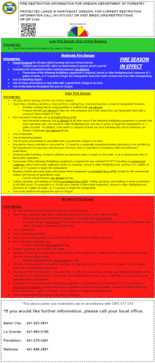
Fire Restriction Information for Oregon Department of Forestry
Other Fire News
Pacific Northwest Large Fire Map
Misson
Our mission at BMIDC is to provide a service for our users through committed leadership, personal dedication and passion for the safety of all those we serve
It is our commitment to provide efficient and effective response while insuring the safety of the public, our natural resource employees, and our wildland firefighters. We strive to provide, reliable, courteous, responsive and professional communications services.
 |
 |
| Wildland Firefighter Foundation | Wildland Fire Application Portal |


